About Me
Hi there, I am Yongchuan Cui (崔永川) !
Currently, I am pursuing a master’s degree at University of Chinese Academy of Sciences and Aerospace Information Research Institute, Chinese Academy of Sciences. Prior to this, I earned my bachelor’s degree from School of Computer Science, China University of Geosciences, where I laid the foundation for my academic journey. I am now heading to the University of Hong Kong to pursue a PhD degree.
My research interests span across computer vision, remote sensing image processing, AI4EO, etc. I am passionate about exploring innovative solutions to complex problems and collaborating with like-minded researchers to push the boundaries of knowledge. If you are interested in my work or have any opportunities that align with my research interests, feel free to reach out! I am always open to new collaborations and discussions.
🔥 News
2025.11: 🎉🎉 One paper has been accepted to IEEE TGRS, 2025.
2025.11: 🏆🏆 Obtain China National Scholarship, 2025 (Top 0.2%) (国家奖学金).
2025.09: 🎉🎉 One paper has been accepted to Information Fusion, 2026.
2025.06: 🎉🎉 One paper has been accepted to International Conference on Computer Vision (ICCV), 2025.
2025.05: 🎉🎉 Receiving the Outstanding Graduate Student Scholarship (13 Recipients in Total), Spring, 2025. link
2025.03: 🎉🎉 Two papers have been accepted by IEEE International Geoscience and Remote Sensing Symposium, 2025.
2024.11: 🎉🎉 One paper has been accepted by ISPRS Journal of Photogrammetry and Remote Sensing.
2024.11: 🏆🏆 Obtain China National Scholarship, 2024 (Top 0.2%) (国家奖学金).
2024.10: 📖📖 Attending the award ceremony at the 8th Space Information Networks Symposium held in Hangzhou, Zhejiang.
2024.10: 🏆🏆 Obtain Third Prize, Rank 5/229, NSFC Remote Sensing Image Intelligent Processing Algorithm Contest, Cloud Removal Track.
2024.09: 🎉🎉 One paper has been accepted by IEEE Journal of Selected Topics in Applied Earth Observations and Remote Sensing.
2024.08: 🎉🎉 One paper has been accepted by IEEE Transactions on Geoscience and Remote Sensing.
2024.06: 🏆🏆 Obtain Merit Student of University of Chinese Academy of Sciences (中国科学院大学三好学生).
2023.09: 🎉🎉 One paper has been accepted by IEEE Geoscience and Remote Sensing Letters.
🔍️ Research Interests
Low-level Vision Foundaton Models
- Addressing the limitations of traditional task-specific or dataset-biased methods by building foundation models for low-level vision remote sensing tasks (e.g., denoising, super-resolution) that learn universal representations from large-scale, multimodal visual data, akin to breakthroughs in CV (e.g., CLIP, LLaVA).
Generalizable Low-level Vision
Developing robust and adaptive algorithms for low-level vision tasks that generalize across diverse scenarios, including varying sensors, imaging conditions, and degradations, etc.
Harmonizing data-driven deep learning with model-driven priors (e.g., physical degradation models, optimization frameworks) to enhance interpretability, efficiency, and robustness.
📖 Education
2023.09 - present : Pursuing a master’s degree in School of Electronic, Electrical and Communication, University of Chinese Academy of Sciences (UCAS) and Aerospace Information Research Institute, Chinese Academy of Sciences (AIRCAS)
- Major: Signal and Information Processing
- Thesis: Research on Low-level Vision Foundaton Models for Universal Remote Sensing Image Restoration Tasks
2019.09 - 2023.06 : B.E. in School of Computer Science, hina University of Geosciences (CUG)
- Major: Data Science and Big Data Technology
- Thesis: Remote Sensing Image Missing Data Restoration Using Generative Adversarial Networks
📝 Publications
Acceptance
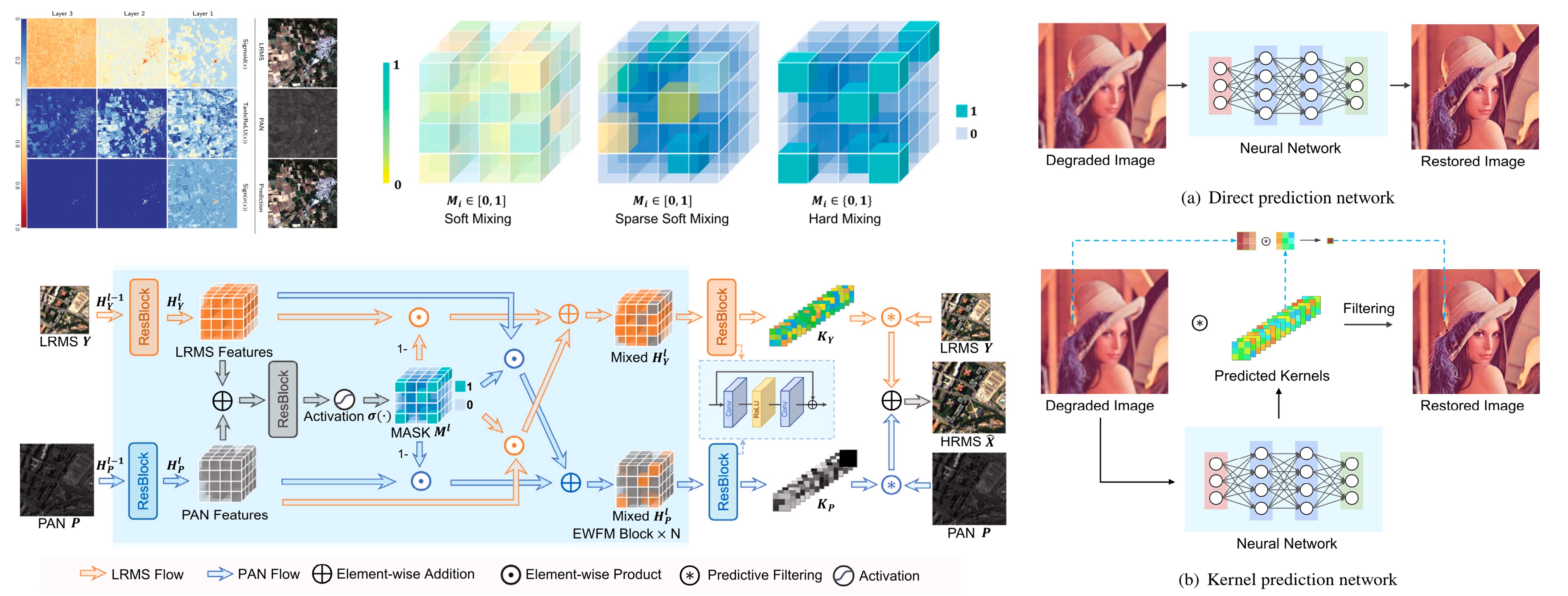
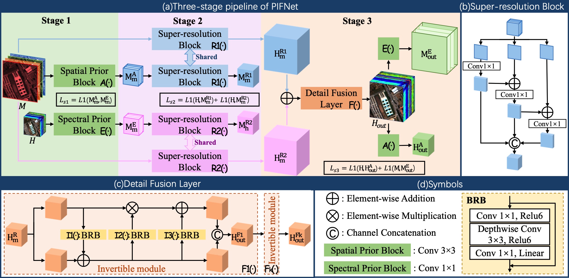
Pansharpening via Predictive Filtering with Element-wise Feature Mixing
Yongchuan Cui, Peng Liu†, Yan Ma, Lajiao Chen, Mengzhen Xu, Xingyan Guo
ISPRS Journal of Photogrammetry and Remote Sensing
📌 Image Fusion 📌 Pansharpening 📌 Low-level Vision
📖 Paper 🗒 BibTex 💻 Code
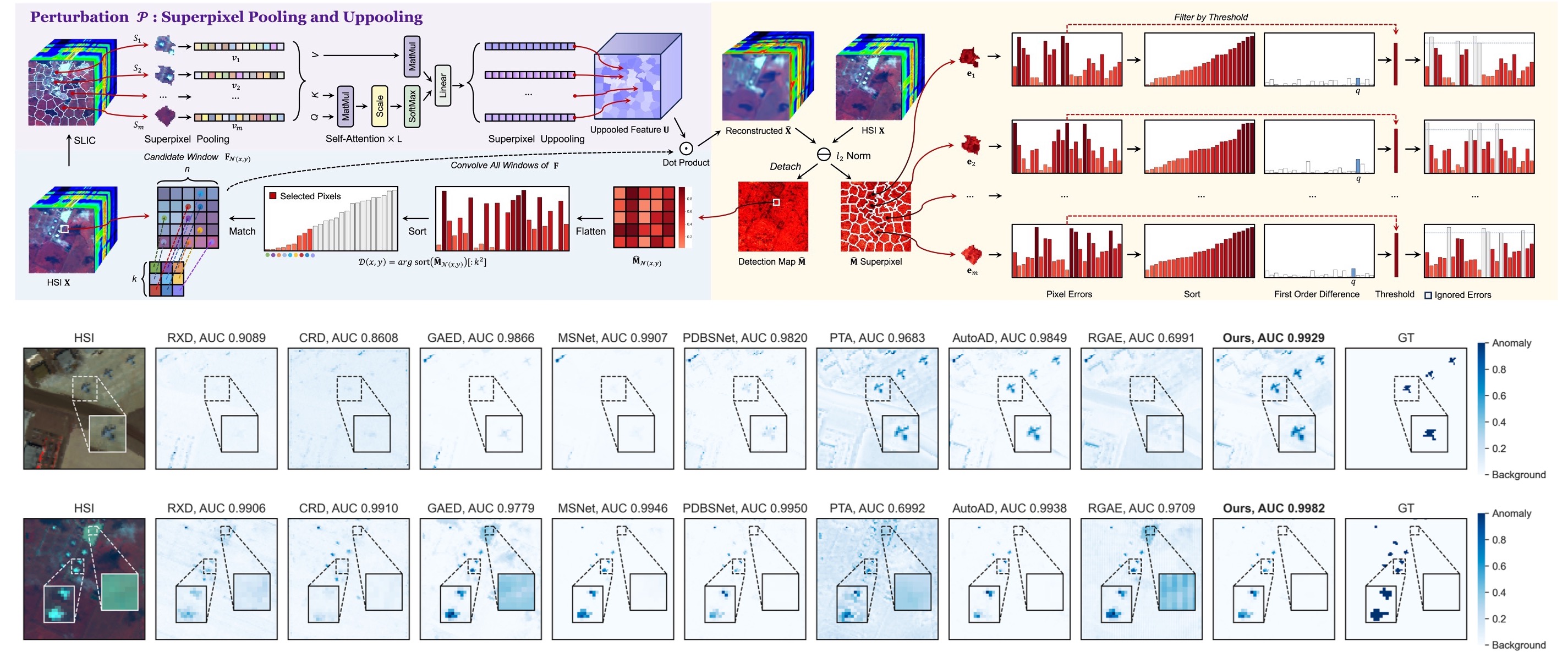
Rethinking Identity Mapping in Self-Supervised Hyperspectral Anomaly Detection: A Unified Perspective on Network Optimization
Yongchuan Cui, Jinhe Zhang, Peng Liu†, Yan Ma, Yi Zeng
The 45th IEEE International Geoscience and Remote Sensing Symposium, 2025
📌 Hyperspectral Anomaly Detection 📌 Self-supervised Learning
💻 Code
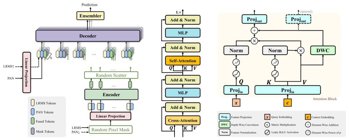
Pixel-wise Ensembled Masked Autoencoder for Multispectral Pansharpening
Yongchuan Cui, Peng Liu†, Yan Ma, Lajiao Chen, Mengzhen Xu, Xingyan Guo
IEEE Transactions on Geoscience and Remote Sensing
📌 Image Fusion 📌 Pansharpening 📌 Generalization
📖 Paper 🗒 BibTex 💻 Code
Reconstruction of Large-Scale Missing Data in Remote Sensing Images Using Extend-GAN
Yongchuan Cui, Peng Liu†, Bingze Song, Lingjun Zhao, Yan Ma, Lajiao Chen
IEEE Geoscience and Remote Sensing Letters
📌 Generative Adversarial Networks 📌 Image Restoration
📖 Paper 🗒 BibTex 💻 Code
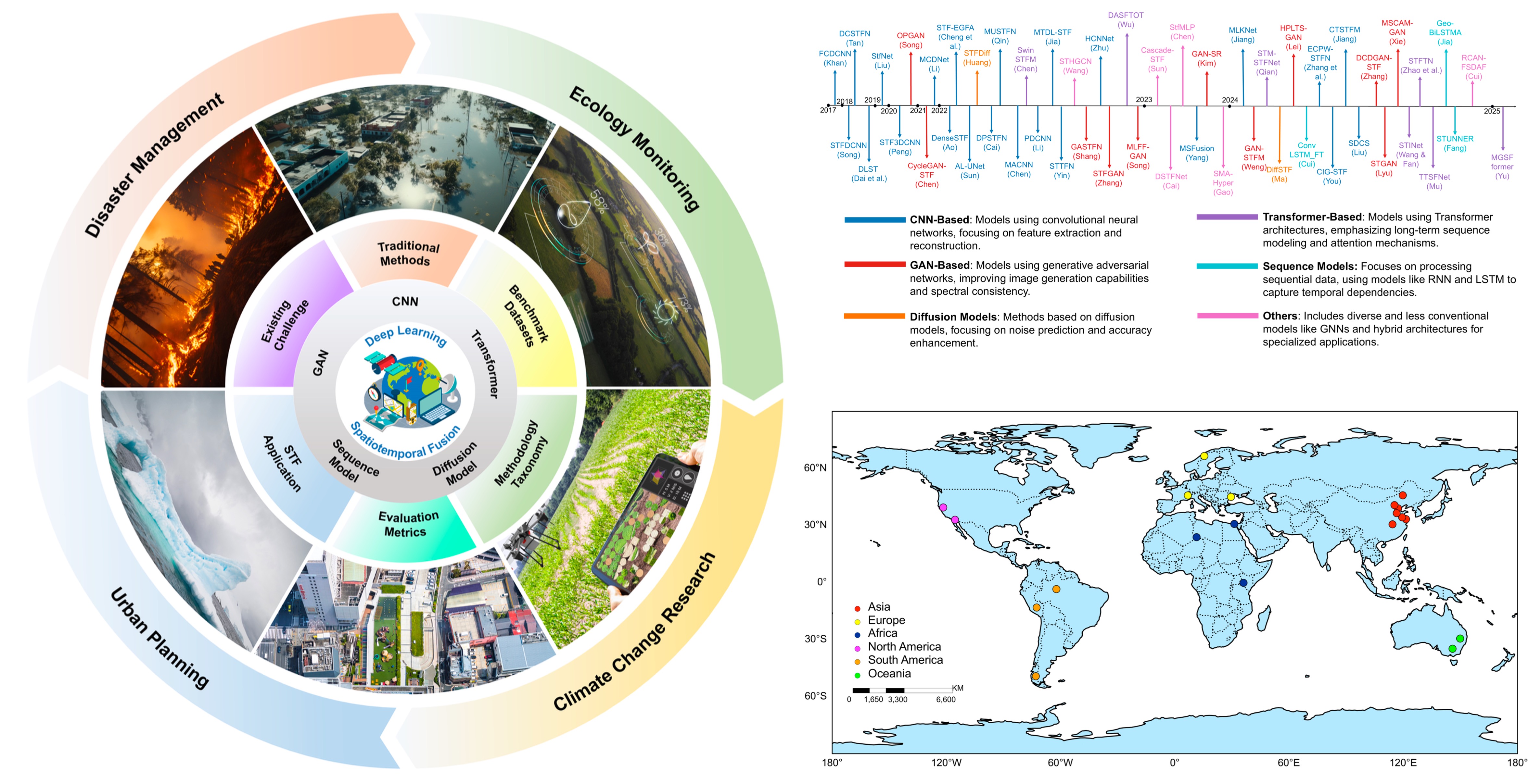
A Decade of Deep Learning for Remote Sensing Spatiotemporal Fusion: Advances, Challenges, and Opportunities
Enzhe Sun*, Yongchuan Cui *, Peng Liu†, Jining Yan†
Information-Fusion
📌 Spatiotemporal Fusion 📌 Model Survey
💻 Repo 🔊 Paper 🗒 BibTex
Enhancing GNSS Positioning in Urban Environments: A Transformer-Based NLOS Detection and Adaptive Weighting Approach
Weiwei Zhai, Yongchuan Cui, Liang Wang†, Ningbo Wang, Zishen Li, Peng Liu, Hang Zhong
IEEE Internet of Things Journal
📌 Signal Classification 📌 Mixture-of-experts 📌 Transformer
📖 Paper
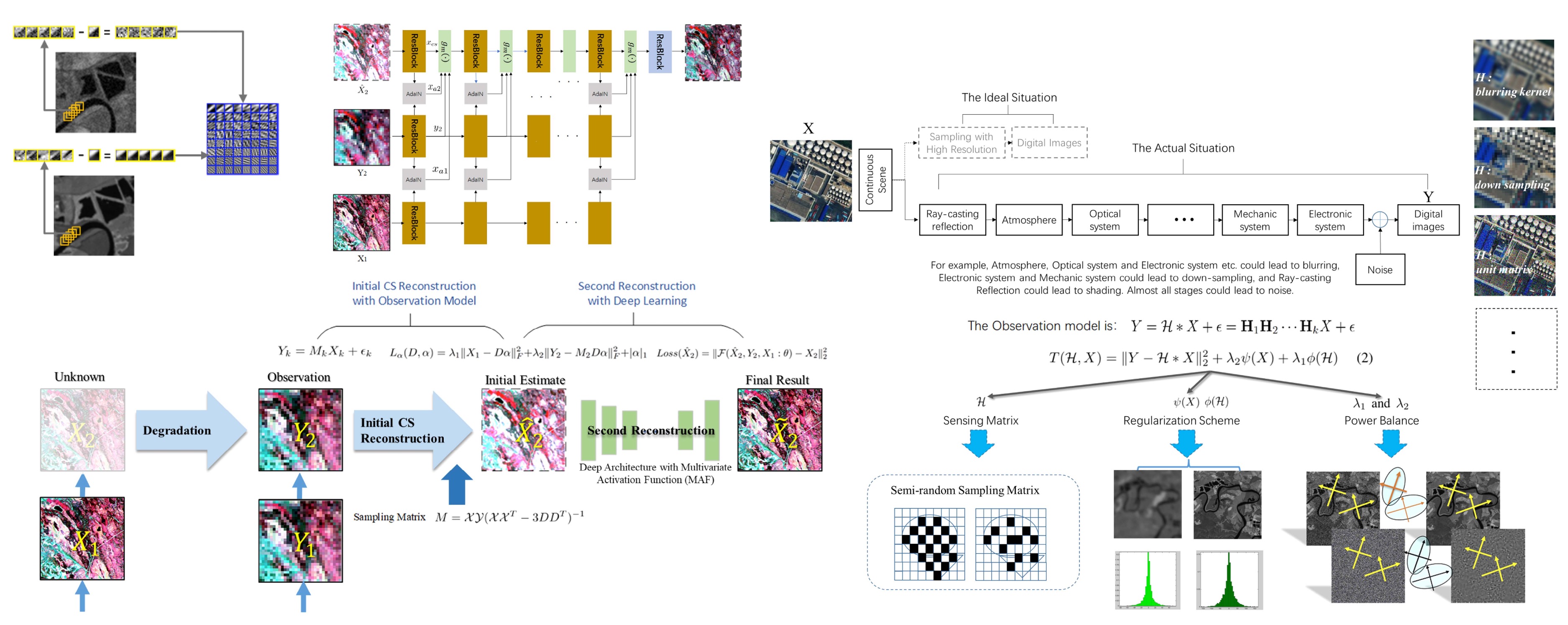
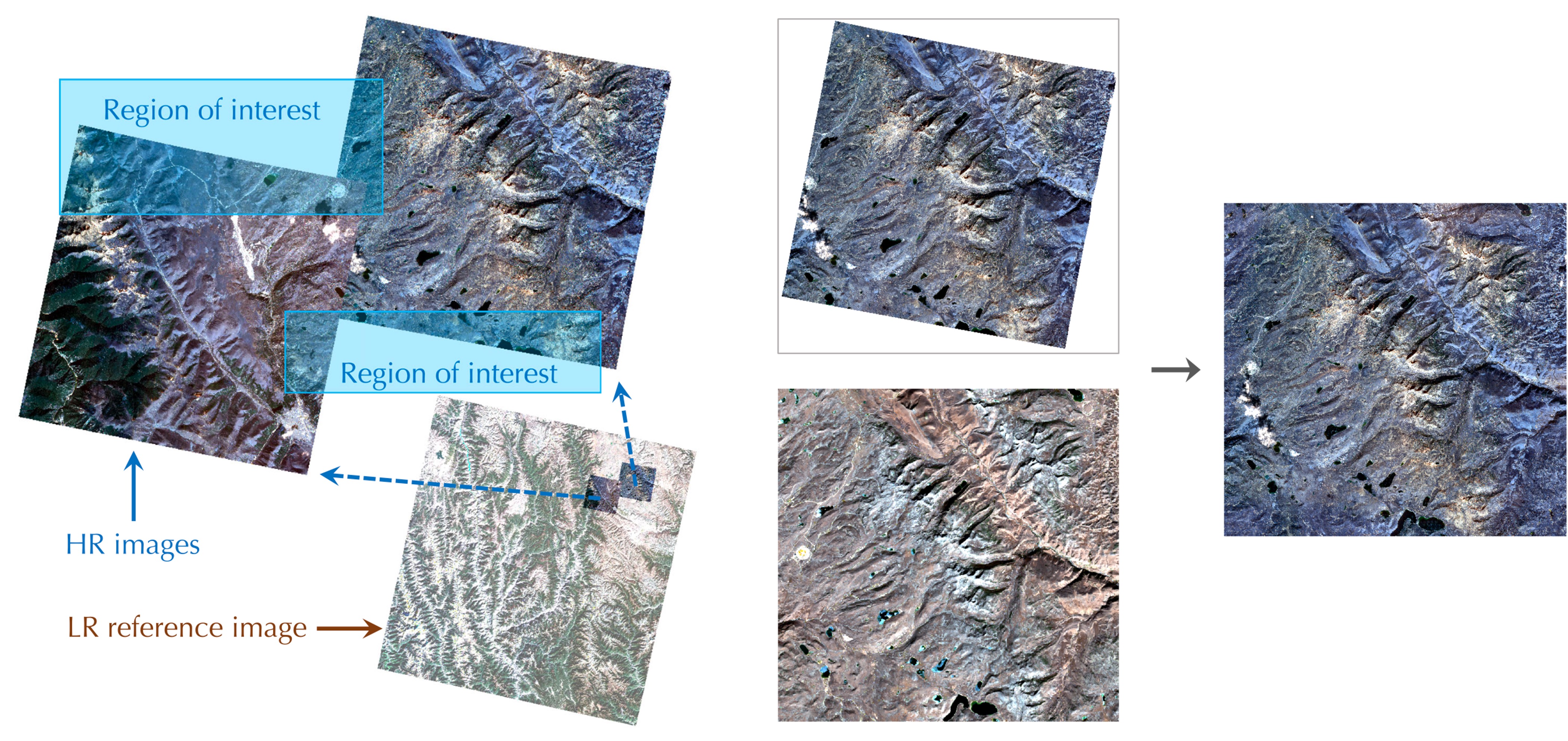
Semiblind Compressed Sensing: A Bidirectional-Driven Method for Spatiotemporal Fusion of Remote Sensing Images
Peng Liu, Lizhe Wang†, Jia Chen, Yongchuan Cui
IEEE Journal of Selected Topics in Applied Earth Observations and Remote Sensing
📌 Spatiotemporal Fusion 📌 Intelligent Evaluation Technique 📌 AI4Science
📖 Paper 🗒 BibTex 💻 Code
Prior-based Three-stage Unsupervised Invertible Neural Network for Hyperspectral and Multispectral Image Fusion
Mengnan Jin, Wenjuan Zhang†, Yongchuan Cui, Jie Pan, Dailiang Peng
The 45th IEEE International Geoscience and Remote Sensing Symposium, 2025
📌 Image Fusion 📌 Unsupervised Learning 📌 Hyperspectral Image Processing
⚙️ Projects
Multi-source Remote Sensing Interactive Intelligent Annotation System
Content: This project focuses on developing an interactive intelligent annotation system for remote sensing images, particularly for river channels, based on the open-source CVAT annotation tool. The system supports multi-source and multi-band data, enhancing annotation efficiency and accuracy. My role centers on the frontend development of interactive point-based annotation techniques, allowing users to annotate images with simple clicks. We’ve also deployed various deep learning segmentation models on the backend for frontend use. The project is supported by the National Natural Science Foundation of China.
Tech Stack: React, PostgreSQL, Redis, MapServer, Django, OpenLayers, GDAL
Distributed Remote Sensing Land Use and Land Cover Classification System
Content: This project presents the design and implementation of a distributed remote sensing Land Use and Land Cover (LULC) classification system. It covers the storage and management of remote sensing data, the construction of query indexes, the design of classification algorithms, and the development of a user-friendly interface. The system utilizes GDAL for data preprocessing, MinIO for distributed storage, MapServer for web map services, and FastAPI for the backend, enabling efficient recognition of building, vegetation, and water bodies through normalized difference indices (NDVI, NDWI, NDBI) from Landsat-8 OLI imagery.
Tech Stack: GDAL, EarthPy, Arcgis (ArcPy), MinIO, MapServer, OpenLayers, FastAPI, Vite+React+Ant
Jetson Xavier NX: Edge AI Development Odyssey
Content: This project aims to conduct a series of experiments and deploy diverse deep learning models on the Nvidia Jetson Xavier NX, an edge computing device, from scratch. Six tasks including face/expression/gait/age and gender recognition, image style transfer, and stereo depth estimation, were included. Additionally, I deployed YOLOv5, trained on self-collected data and accelerated with TensorRT’s FP32, FP16, and INT8 on the development board. Results showed FP32 could boost FPS from 17.67 to 40.34 with almost no accuracy loss.
Tech Stack: Nvidia Jetson Xavier NX, PyTorch, OpenCV, Face Recognition, TensorRT, Docker, YOLOv5
🏆 Honors and Awards
2025 China National Scholarship (国家奖学金)
2025 Outstanding Graduate Student Scholarship (13 Recipients in Total)
2024 China National Scholarship (国家奖学金)
2024 Third Prize, Rank 5/229, NSFC Remote Sensing Image Intelligent Processing Algorithm Contest, Cloud Removal Track
2024 Merit Student of University of Chinese Academy of Sciences
2023 Outstanding Graduate of China University of Geosciences (Wuhan)
2022 National Third Prize, “Challenge Cup” National College Student Extracurricular Academic and Technological Works Competition (全国三等奖, “挑战杯”全国大学生课外学术科技作品竞赛)
2021 Specially Invited Student Guest, Huawei CONNECT (华为全联接特邀学生嘉宾)
2021 Third Prize, National Finals of the Huawei ICT Competition, Innovation Track (全国三等奖, 华为 ICT 大赛创新赛)
2021 Huawei Research & Innovation Scholarship (华为科研创新奖学金)
🧑💻 Activities and Services
Reviewer
- Journals:
- IEEE TGRS
- ISPRS J P&RS
- Signal, Image and Video Processing
- Cognitive Computation
- Nature Partner Journals: Heritage Science
- Multimedia Systems
- Conferences:
- AAAI
✉️ Contact
- cuiyongchuan23@mails.ucas.ac.cn
- yongchuancui@gmail.com (preferred)
© Yongchuan Cui | Last updated: 09/2025